Via Alpina Eastern Switzerland
The three-stage Via Alpina trail starts as Via Alpina Eastern Switzerland in eastern Switzerland - in Vaduz in the Principality of Liechtenstein to be more precise. One walk to the modern museum buildings in the city centre, which are a superb contrast to the princely palace, and you start off on the long-distance hike to Montreux.
The route passes the foot of the mighty Gonzen, gives you a sneak peak of the Sargans Castle and crosses the main valley to start the ascent towards the steep, remote Weisstannen valley. It is strewn with hidden gems such as the romantic Champersee lake. This is the place for a well-deserved break before hiking on to Weisstannen. Remote or not, milk from the neighbouring Alps is piped to Alp Siez, almost as if by a pneumatic tube. However, this innovation is not enough: the terraced Alp huts on the other side of the Foo Pass are an architectural rarity. Hikers are now in Glarus and get their well-deserved night's rest in Elm. Well deserved, because the stretch that they have covered so far demands a lot of fitness and surefootedness.
Between Elm and Linthal, those interested in geology will find a place they will enjoy. This is the GeoPark, where the genesis of the Alps can be seen from the Glarus thrust, a strange, easily recognisable line along the rock faces around Piz Sardona.
After packing such geological information about the formation of the Alps in your rucksack, you are inspired to move faster on the Via Alpina - up and down the Glarus Alps, first through the Richetli Pass near the Leglerhütte and then down into the lonely Durnachtal. Linthal, the end point of Via Alpina Eastern Switzerland, is not too far from here.
Via Alpina Central Switzerland
The second stage of the long-distance hike is called Via Alpina Central Switzerland. It takes you from the Glarus Alps to the Bernese Oberland. The route passes through the wildest mountain regions of Switzerland. Some sections are challenging, but not so much that you miss out on the surrounding beauty.
You come across two highlights right at the beginning: from Linthal, the trail takes you up to the sun terrace of Brunwald and from there to the largest Swiss Alp Urnerboden. The extensive area below the Klausen Pass is a proud home to about 12,000 cows. Via Alpina crosses the Klausen Pass and then runs on a mountain trail high above the Schächental, only to descend steeply to the valley floor to Unterschächen. After a transfer, hikers go on a short hike in Altdorf and then use the cable car to climb up to Brüsti and hike on a ridge over the historic Surenen Pass to go on to Engelberg. The beautifully sparkling Lake Trübsee is located two altitudinal belts above the monastery village at the foot of Titlis.
From here you hike across the Joch Pass into the Bernese Oberland to Engstlenalp, which gets it charm from the idyllic lake, grazing cows and countless Alpine roses. The third lake in a short span of time on this route is located on Tannalp, which houses an inn and a cheese dairy, where you can give yourself a wonderful treat.
After refreshing yourself with Alpine cheese and cakes, you take the ridge walk over Balmeregghorn with a view of the big three mountains of Eiger, Mönch and Jungfrau. Dwarf trail Muggestutz and a sculpture garden offer variety on the last stretch to Meiringen, which is the end point of Via Alpina Central Switzerland.
Via Alpina “Bärentrek”
The third stage of the long-distance hike from Vaduz to Montreux is called Via Alpina “Bärentrek” (bear trek). Hikers are now in the spectacular region of Eiger, Mönch and Jungfrau. Once upon a time, it was a pathless region, which could only be traversed by wild animals, probably even bears. Hence the name “bear trek”. Although the area now has a network of well-developed hiking trails, hikers should always be careful because they still need to cross some passes and steep or narrow areas.
The tour starts in Rosenlaui and takes you across the Grosse Scheidegg to Grindelwald. The panorama view of Eiger, Mönch and Jungfrau is breathtaking. It is a pleasure to remember that it is such charismatic mountains that first attracted mountaineers and that their beauty brought tourism into the region. From Grindelwald you hike up to Kleine Scheidegg and take the sunny mountain trail to Wengen.
Those who climb down the valley looking at the waterfalls, remember what Lauterbrunnen exactly means: while the meaning of “brunnen” is spring or fountain, “lauter” could be interpreted as “louder” or “clear”. No wonder you can hear gushing and gurgling sounds everywhere in this valley. The rock faces are steep and thus many hikers prefer to take the train down to Mürren. There’s a lot more to trek even after that: the route passes the Sefinenfurgge amidst truly Alpine scenery to Griesalp in the rear part of Kiental, a side valley of the Kandertal.
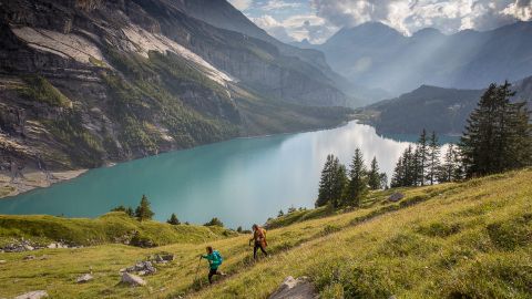
It is now time for the royal stage - the long, steep climb to Hohtürli, the pass crossing between Kiental and Kandertal, is quite demanding. Fortunately, one can replenish their energy with the fine regional specialities that Blüemlisalphütte has to offer. You can hike down the moraines of the Blüemlisalp Glacier to Oeschinen Lake, which is spectacularly surrounded by steep rock faces. A dip in the cool mountain lake can be extremely rejuvenating and the last few kilometres down to Kandersteg vanish in no time.
But the next leg is again difficult; although the cable car takes hikers up to Allmenalp, this is followed by an ascent to Bonderchrinde, which is a difficult climb but totally worth it: the Alpine panorama is unparalleled. This is an ideal spot to spend some time and soak in the beauty before starting the descent to Adelboden. A shorter leg through the Hahnenmoos Pass into the Simmental concludes the Via Alpina “bear trek”.
Via Alpina Western Switzerland
The fourth and last stage of the long-distance hike is called Via Alpina Western Switzerland from Lenk to Montreux. The stretch has something in store for everyone: if the hike has not tired you out yet and you are keen on more challenges, you will long for the steep ascents. If you are a connoisseur, you will hardly be able to wait to taste the cheese made on fire in the Alpine huts. Maybe the Via Alpina hikers are both: summiteers as well as connoisseurs.
After leaving Lenk behind, hikers roam across the soft Alpine pastures and through the lynx region and wet limestone karren area. This is the right time to digest the previous stages and prepare mentally for the next challenge which immediately surfaces in the form of a steep climb to Trüttlisberg Pass and proves to be quite testing for hikers. The day again ends in a valley, in the upscale resort town of Gstaad, where you can indulge in culinary delights and take sufficient rest.
The next day starts with a hike on a scenic mountain trail, leaving behind Gstaad in the valley, taking a break at the Eggli mountain lodge, then moving on to the language border at Col de Jable via Wilde Bode. There are many Alpine huts with large shingle roofs that make excellent Alpine cheese in their large cheese dairies. But be sure to ask for “fromage” and not “cheese” anymore because you have crossed the language border. You then cross Gorges du Pissot to reach the great valley of Pays d'Enhaut. A short stroll through the pretty town of Châteaux-d'Oex before going down to Rossinière pays off.
An experienced hiker can now almost smell Lake Geneva in the air. A brisk walk over the historic bridge from 1650 takes you to Col de Solomon and then to Col de Chaude, where you get to see the first glimpse of Lake Geneva. The last leg of Via Alpina ends at the mountain station of the Rochers de Naye cog railway. It is advisable to cover the last part of the journey by train - not just to cool down your joints. No. The train ride offers an incomparable view of the sparkling Lake Geneva, every metre of which can be enjoyed to the fullest on the way down to Montreux.
.jpg/jcr:content/ST0050149_Spannort_Attinghausen.jpg)
.jpg/jcr:content/ST0050154_Bundalp-(ST).jpg)
.jpg/jcr:content/ST0051327_Urnerboden_Klausenpass.jpg)


.jpg/jcr:content/ST0050342_Engstlensee-(ST).jpg)
.jpg/jcr:content/ST0050340_Grosse_Scheidegg-(ST).jpg)

.jpg/jcr:content/ST0051405_Rocher_de_Naye-ST.jpg)

.jpg/jcr:content/sts0041474_Oeschinensee-(ST).jpg)
.jpg/jcr:content/ST0050336_Schwarzwaldalp-(ST).jpg)
.jpg/jcr:content/ST0050148_Spannorthuette.jpg)
.jpg/jcr:content/ST0050216_Engstlensee.jpg)
.jpg/jcr:content/ST0051288_Aufstieg_Col_de_Jable-(ST).jpg)